Marine Geophysical Methods
There are several geophysical techniques which are specifically
designed for use over water. Other typically land-based geophysical
techniques such as ground penetrating radar, seismic refraction, and
electrical resistivity profiling can be adapted for use in water. All of these techniques require the use
of a boat and an accurate method for determining position during
data acquisition. Differential global position systems (DGPS) are
typically used for providing real time location data. Each of the
techniques that are commonly used by Earth Dynamics are summarized below:
ACOUSTIC SUB-BOTTOM PROFILING
Acoustic Sub-bottom Profiling is a geophysical technique that can
be used to determine sub-bottom stratigraphy. Sub-bottom profiling
systems consist of an acoustic source, an array of hydrophones and a
recording system. The source emits acoustic energy into the water.
The energy is reflected off interfaces where the velocity of the
energy changes. The reflected energy is detected by the hydrophones
and the data are stored by the recording system.
-
"CHIRP" SUB-BOTTOM PROFILER
CHIRP systems employ wideband frequency modulated (FM) “Chirp” technology. The
system transmits a linearly swept, wide band FM pulse into the water (commonly termed the “chirp” pulse). When the acoustic pulse encounters material with different acoustic properties, a portion of the energy is reflected. Reflections are received by the tow-fish and are processed to remove the FM carrier. The measured reflections are displayed in real time as shades of gray on a computer monitor, and are stored on a hard drive for post processing. This technique provides penetration that is comparable to low frequency narrow band systems with resolution comparable to high frequency narrow band systems.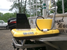
Chirp Tow-fish
-
BUBBLE PULSER
The bubble pulser is a compact, high efficiency, low frequency, seismic reflection profiling system. It is specifically designed to map thicknesses of sedimentary layers and the depth to bedrock in marine environments. Typically, the system is capable of penetrating 100 feet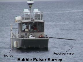 of material
with a resolution of five feet. Use of the bubble pulser is limited
to areas where the water depth is at least eight feet.
of material
with a resolution of five feet. Use of the bubble pulser is limited
to areas where the water depth is at least eight feet.
The system consists of a pulser with a resonant frequency of 300 Hz, a single channel seismic streamer and a graphic or digital recorder. The pulser and streamer are towed behind or next to a moving vessel. The pulser provides a seismic pulse approximately every second. The seismic pulses travel through the water and are reflected back to the surface from subsurface seismic interfaces. The reflected signal is detected by the seismic streamer. The seismic streamer signal is processed and recorded on a graphic or digital recorder. The amplitude of the reflected signal depends upon the velocity contrast between the various layers. The depths to the seismic interfaces can be computed from the travel times for the reflected waves in the velocity of the subsurface material is known or if the survey intersects an area of known geology. -
kHz SUB-BOTTOM PROFILER
The theory of operation of the kHz sub-bottom profiler and the bubble pulser are the same, and the amount of energy produced by the sources in each of the systems is approximately equal. The difference is that kHz systems are tuned to a higher frequency than the bubble pulser. The increased frequency provides higher resolution of sub-bottom structures. However, the higher frequency also results in a decrease in penetration depth. This method is particularly useful for locating hard rock outcrops in areas of thinly bedded fine grained sediments. The kHz sub-bottom profiler requires a minimum water depth of six feet and it can be used to water depths of hundreds of feet.
MARINE ELECTRICAL RESISTIVITY
A marine electrical resistivity survey is similar to a terrestrial
survey except that a specially constructed marine multi-electrode cable is placed on the
bottom of the water body. The cable consists of twenty-five electrodes. An Advanced
Geosciences, Inc. control unit applies current and measures the
potential from various pairs of electrodes to determine electrical
resistivity as a function of depth along the electrode array. The
data are processed using a two-dimensional inversion program. In the
program, a non-linear least-squares optimization technique is used
to automatically determine the best fit to the data. This method is
useful in determining the geologic conditions below the mudline. For
more information on this method, see our
Electrical Resistivity
page.
GROUND PENETRATING RADAR
Ground penetrating radar (GPR) uses FM-frequency radio energy to
echo-locate subsurface features. Additional details of the technique are
described in the GPR section. The technique was originally
developed to investigate subsurface features below ice sheets. The
GPR method has been adapted for use over land or water. Over-water
surveys are conducted by placing the radar antennae in rubber rafts.
The rafts are towed behind or beside a moving vessel. Generally the
GPR method is useful in fresh water at water depths ranging from a few
feet to twenty feet. Beyond twenty feet there is insufficient signal
strength from most antennae to penetrate the sub-bottom material.
SIDE SCAN SONAR
Side scan sonar is useful for mapping underwater topography and for
identifying features on the surface of river and lake bottoms. The
technique is capable of providing data to over one thousand feet on
both sides of a moving vessel. A side scan sonar survey consists of
towing a transmitter/receiver (towfish) from a moving vessel. The
towfish transmits high intensity, high frequency bursts of acoustic
energy into the water. The acoustic energy is transmitted in
fan-shaped beams which are narrow in the horizontal plane and wide
in the vertical plane. Objects or topographic features on the river
bottom produce echoes which are received by the towfish. The signals
are processed and printed on a graphic recorder or stored in a
digital format. Generally, hard materials provide high amplitude
echoes and soft, fine grained materials provide weak signals. Side
scan sonar produces a visual representation of the bottom of the
body of water.