THE GROUND PENETRATING RADAR (GPR) METHOD
The GPR method provides information which can be used to help
determine:
- The location and depth of metallic and non-metallic buried objects such as voids, utilities, pipes, drums, tanks, cables and boulders
- The presence of rebar in concrete
- The extent of contaminant plumes
- The location of archaeological sites
- The condition of brick, masonry and concrete structures
- The condition of sub-grades beneath roads, railroad tracks, and runways
- The boundaries of buried landfills and trenches
- Depth and thickness of soil strata on land and under fresh water
- Bedrock topography
- Depth to the water table
In a GPR survey, high frequency (10 MHz to 3,000 MHz) electromagnetic (EM) pulses are used to detect changes in EM properties (dielectric permittivity, conductivity and magnetic permeability)
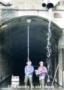 |
| GPR survey in irrigation tunnel to evaluate the condition of the concrete liner and to detect voids behind the liner. |
The lateral resolution of a GPR survey depends upon the spacing of the GPR profiles and the rate at which data is collected along the profile. The vertical resolution of the technique is a complex function of the amplitude and wavelength of the EM pulse, the propagation characteristics of the host material and the target, the complexity of the geology, noise from manmade and natural sources, and the depth shape and size of the target. Typically, vertical resolution of a few centimeters can be obtained with high frequency antennas (1 GHz) at depths of less than one meter, while lower frequency antennas (10 MHz) may have a resolution of a meter or so at depths to over fifty meters. Penetration depths of 5,000 meters have been achieved under certain conditions such as polar ice or salt deposits.
The GPR method is limited to areas which do not contain high conductivity soils, or sediments which are saturated with salt water or other highly conductive fluids.
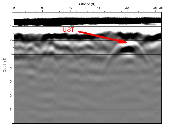
GPR data showing reflection from underground storage tank.