Downhole Seismic Velocity Measurement Methods
| This method is
commonly used to determine compressional and shear wave
velocity versus depth. These velocity data are used to
help asses the geology and seismic response of a
particular site. (See the ReMi
method for
site-specific NEHRP/IBC soil classification without the
need for a specially cased boring.) In a downhole seismic survey, a seismic source is placed on the surface near a borehole, and two tri-axial geophones are placed at selected depths in the borehole. The raw data obtained from a downhole survey are the travel times for compressional and shear waves from the source to the geophones and the distance between the source and geophones.
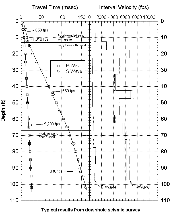
The downhole sensors consist of two triaxial geophone assemblies. Each assembly contains three sensing elements: one vertical and two orthogonal horizontal elements. The geophone assemblies are separated by a distance of five or ten feet. Two geophone assemblies at a fixed separation are used so that interval velocities can be determined from the same set of impulses. This method reduces timing errors caused by differences in seismic triggering and variations in source impulse characteristics. The data are analyzed by determining the interval velocity for each geophone placement. Interval velocity is determined by first computing the distance from the source to each geophone and the difference in arrival times between the upper and lower geophones. The interval velocity is computed by dividing the difference in distance between the geophones by the difference in arrival times. The interval velocity is then plotted as a function of depth. Typical travel time plot and velocity profiles are shown in the figure below:
|